Habitat Monitoring
Turn Satellite Imagery Into High-Resolution Maps With AI-Powered Habitat Monitoring Software
Map and monitor ecosystem structure at scale using our AI-powered habitat mapping software. Our GIS habitat mapping tool applies satellite imagery analytics and machine learning to classify habitat types, detect change over time, and overlay with ecological sensor data.
Trusted by Leading Organisations Around the World


Transform Satellite Imagery into High-Resolution Habitat Maps and Detect Habitat Change Over Time
Our habitat mapping software uses machine learning models to detect and classify landscape types, including forest, wetlands, grasslands, scrub, water bodies, directly from satellite imagery. We layer in elevation, slope, and contextual habitat rules to refine classifications, delivering maps that are ready for analysis, planning, or integration with species data. Each result is validated by expert review to ensure accuracy and usability in GIS habitat mapping workflows.
Generate habitat classes by leveraging multispectral bands, topographic layers, and land-cover rules.
Segment large imagery in tiles, run classification, and stitch results automatically.
Automatically flag areas that exceed threshold changes for action or compliance.


Convert Habitat Maps Into Actionable Insights with Satellite Imagery Analytics
Once habitat maps are generated, our habitat monitoring software applies change detection and spatial analysis to reveal where ecosystems are shifting, degrading, or regenerating. By comparing multiple satellite imagery epochs and class maps, you can surface trends like habitat loss, fragmentation, or recovery zones. Each habitat change output carries a confidence score and links back to raw imagery and classification metadata, making results verifiable and ready for GIS habitat mapping workflows.
Automatically compare habitat maps across time slices to detect subtle changes.
Distinguish types of habitat change (e.g. forest to grassland, wetland shrinkage) and flag high-risk areas.
Every detected change includes uncertainty metadata and full traceability to source layers for validation.
Seamlessly Integrate Habitat Maps into GIS Workflows for Deeper Insight
Our habitat mapping software doesn’t just create maps, it fully integrates with GIS systems and spatial analysis workflows. Export classification layers, mask overlays, and contextual datasets into standard GIS formats. Use spatial tools to combine habitat maps with elevation, hydrology, infrastructure layers, and biodiversity data. Unlock deeper insights through spatial metrics like area, connectivity, fragmentation, and adjacency, all within a workflow built for GIS habitat mapping and satellite imagery analytics.
Merge habitat classification with elevation, slope, hydrology, land cover, and built infrastructure in spatial overlays.
Calculate metrics such as habitat fragmentation, connectivity, patch size, and edge density for reporting or decision support.
Export interoperable GIS formats (GeoTIFF, shapefile, vector layers) compatible with ArcGIS, QGIS, and other habitat mapping platforms.
.avif)
Fully Integrated Habitat Mapping Workflow in Four Steps
Our habitat mapping software turns raw satellite imagery into validated habitat maps through a streamlined, four-step process. By combining AI, spatial analytics, and expert review, we deliver high-quality habitat classification outputs ready for decision-making, reporting, and further integration.
1.
Import & Prepare Satellite Data
Import satellite imagery (e.g. multispectral, Sentinel, Landsat) alongside ancillary spatial layers (e.g. elevation, land cover). This serves as the base for mapping workflows.
2.
Generate Habitat Classifications
Using AI-driven geospatial models, we classify imagery into habitat types (e.g. forest, wetland, grassland), enhanced by spatial context from additional datasets.
3.
Expert Validation and Review
Ambiguous or uncertain areas can be flagged for expert review. This ensures final habitat maps align with field logic and ecological validity.
4.
Integrate & Export
Final habitat maps are made available to overlay with species or spatial data in your dashboard. Outputs can be used in GIS tools, supporting further analysis and decision workflows.
Habitat Mapping Solutions Tailored For Every Industry & Sector
Every sector has distinct habitat planning, compliance, and restoration requirements. Our habitat mapping software supports organisations in infrastructure, conservation, agriculture, and government, enabling them to visualise, monitor, and manage habitat change with confidence.
.avif)
.avif)
.avif)
Proven Biodiversity Solutions Driving Compliance And Conservation At Scale
From tropical forests to private estates, our biodiversity solutions are used worldwide to deliver measurable results. Explore our case studies on the interactive map to see how we help organisations achieve compliance, conservation and restoration outcomes.
Qatar Marine Monitoring
Okala provided marine biodiversity baselines for coastal mangrove restoration
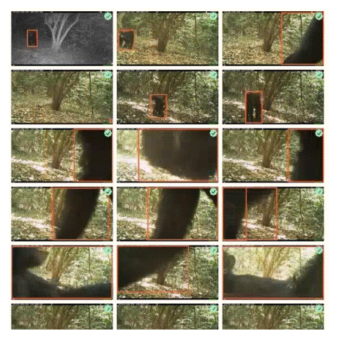
Eastern Africa chimps
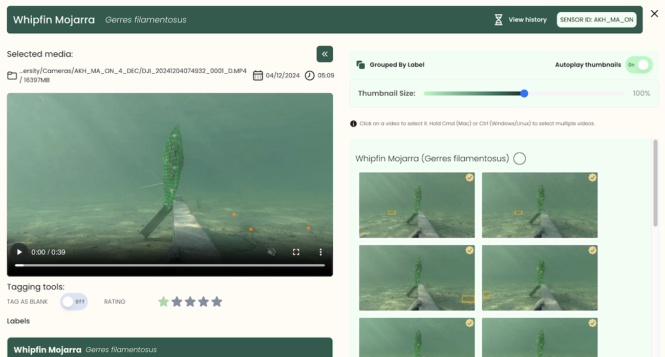
The Biodiversity Consultancy partnered with Okala to monitor chimpanzee populations using camera trap data
Congo rainforest
Scalable AI species identification in the Republic of Congo
EUDR East Africa
EUDR compliance for 50,000 soya farms across Togo and Benin

Gold mine in Australia
FURA is a global gemstone mining company operating in Australia, Colombia, and Mozambique.

Brazil Rainforest
Camera trap videos of individually identified jaguars can support biodiversity credit projects

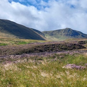
Scottish Estate
Scaling the use of bioacoustics, eDNA and camera traps for biodiversity monitoring in Scotland
Peer-reviewed studies underpinning our methodologies, ensuring outputs are scientifically robust and defensible under regulatory scrutiny.
Projects delivered across Africa, Asia, Europe, and the Americas, supporting approvals, compliance, and measurable biodiversity outcomes.
Agricultural sites assessed for deforestation risk and sustainability reporting, supporting compliance with EUDR and supply chain requirements.
See What Our Clients Say
Hear from organisations we have supported across complex projects, delivering reliable, defensible outcomes under regulatory and operational pressure.
We had a fantastic experience working with Okala, who supported us with camera trap surveys, including survey design, image processing and data analysis. They were extremely professional and communicative, delivering tagged images and access to their expert dashboard within a short space of time. We look forward to working with them on future projects.

We have had a great experience working with Okala. The process has been constructive and efficient. We have appreciated the collaborative nature of the work and the level of expertise from the Okala team. It has been great to work with a like-minded team who share our values.

We greatly appreciated Okala’s ability to adapt to the specific demands of the mining industry. Their flexibility and responsiveness enabled the timely delivery of key project components. The dashboard training session was very well received by our client, and the platform itself has proven to be an effective tool for visualizing the results of camera-trap monitoring. We look forward to continuing and expanding our collaboration with Okala.

This was an ambitious project where we could put AI to the test at very large scales. Okala's data platform allowed us to verify AI outputs and rapidly interact with the data using the intuitive interface.


Okala's expert gap analysis and guidance have greatly advanced Fura’s progress towards reaching our sustainability goals. Their professionalism and insight into biodiversity and carbon management exceeded our expectations.


Okala delivered cutting edge biodiversity, carbon and social baselines to understand how a 300,000 ha forestry concession in Gabon could be managed for sustainable development.


The full service - from fieldwork to reporting - was excellent. We look forward to working with Okala again.

Minimising biodiversity impact is an increasing challenge for our sector. Okala provided unrivalled transparency and reporting for our early-stage industrial project in Rwanda.


Okala delivered high-quality biodiversity baselines in just six months using eDNA, bioacoustics and camera traps. Their work will allow us to calculate the biodiversity value of the forest to inform land-management.

Habitat Mapping Software FAQs
Still have questions about how our habitat mapping software works? Explore the answers below to learn how it can support your ecological workflows from habitat mapping to satellite classification, and GIS integration.
Book A Demo Today To See Our Environmental DNA Monitoring Platform in Action
Export maps, detect change, overlay species data all in one platform. From satellite classification to validation and export, learn how your team can speed up planning, compliance, and ecological decision-making. Book a personalised 30-minute demo to explore our habitat mapping software in your context.
