Biodiversity Assessment Services
End-To-End Biodiversity Assessment Services for Regulatory Approval and Risk Management
Get expert support for delivering robust biodiversity assessments including baseline studies, impact evaluation, and risk analysis to secure regulatory approval and lender requirements. Our approach produces clear, defensible outputs aligned with frameworks such as IFC PS6 and national regulations.
Trusted by Leading Organisations Around the World


Biodiversity Assessment Solutions Across Regulatory Approval, Impact Evaluation and Risk Identification
We support organisations in delivering biodiversity assessments required for regulatory approval, lender due diligence, and project planning, combining baseline data, impact evaluation, and risk analysis to produce clear, defensible outputs that inform decisions and stand up to scrutiny.
Regulatory Approval and Compliance Assessments
Secure planning consent and meet regulatory and lender requirements through biodiversity assessments including EIA, EcIA, and baseline studies, delivering outputs designed to support approvals and withstand review.
Biodiversity and Nature Impact Evaluation
Understand how your project affects species, habitats, and ecosystems through detailed impact assessment, enabling you to identify constraints, quantify impacts, and design effective mitigation strategies.
Biodiversity Risk and Footprint Analysis
Identify biodiversity risks, sensitivities, and project footprint early to support site selection, reduce delays, and align with lender expectations including IFC PS6 and international standards.
Why Our Biodiversity Assessments Are Trusted by Global Organisations for Approval and Compliance
We support organisations across the world operating under regulatory and lender pressure with biodiversity assessments designed to stand up to scrutiny and inform high impact project decisions.
Assessments structured to meet regulatory requirements and lender expectations, reducing approval risk and helping projects move forward without unnecessary delays.
Experience working on projects where timelines, compliance, and environmental risk are critical, ensuring assessments are delivered when they are needed and to the required standard.
Outputs developed using consistent methodologies and clear data structures so they hold up under regulatory review, lender due diligence, and independent audit.
Field surveys, spatial analysis, and ecological expertise combined into a single, coherent dataset that supports confident decision making and avoids fragmented or inconsistent outputs.
Specialist Biodiversity Assessment Services Built for Approval Risk and Scrutiny
When biodiversity assessments need to support approvals, satisfy lender requirements, and stand up to scrutiny, organisations can rely on our specialist expertise. We deliver multiple types of biodiversity assessment depending on your regulatory requirements, project stage, and lender expectations.
Lender grade environmental and biodiversity impact assessments supporting regulatory approval and international project financing requirements.
EcIA services for planning applications and ecological compliance, delivering defensible outputs aligned with national and international standards.
IFC PS6 critical habitat assessments supporting lender due diligence and ensuring compliance with international biodiversity standards.
End-To-End Biodiversity Assessment Services
Pre-development baseline studies establishing defensible biodiversity data required for impact assessment, planning, and regulatory compliance.
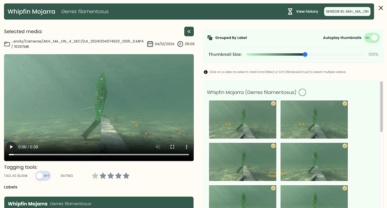
Biodiversity Surveys (Multi-Method)
Multi-method field surveys using camera traps, bioacoustics, eDNA, and traditional techniques to generate high quality ecological data.
Species and Habitat Assessment
Assessment of species, habitats, and ecological sensitivity to support impact evaluation, mitigation planning, and compliance requirements.
Our Structured Approach to Biodiversity Assessment and Approval
Our proven approach is designed to deliver biodiversity assessments that support regulatory approval, satisfy lender requirements, and stand up to scrutiny. From early scoping through to final reporting, we ensure outputs are consistent, defensible, and aligned with project and compliance requirements.
1.
Scoping and Study Design
We define project requirements, regulatory context, and assessment scope including applicable frameworks such as EIA, EcIA, and IFC PS6, ensuring the right approach from the outset.
2.
Data Collection and Baseline Development
We deliver multi method surveys and data collection to establish baseline conditions across species, habitats, and ecological indicators.
3.
Impact Assessment and Risk Analysis
Our team evaluates project impacts, biodiversity sensitivities, and ecological risks to identify constraints, quantify impacts, and inform mitigation strategies.
4.
Reporting and Approval Support
You get structured, audit-ready outputs aligned with regulatory and lender requirements, supporting planning consent, due diligence, and project approval.
Supporting Organisations Globally Across High Impact Sectors
We support organisations operating in regulated, high impact sectors including mining, energy, and infrastructure, where biodiversity compliance requirements are critical to project success.
Supporting complex projects across multiple countries, regions, and regulatory environments.
Experience delivering biodiversity and monitoring programmes across large sites and multi location projects.
.avif)
.avif)
.avif)
Proven Biodiversity Solutions Driving Compliance And Conservation At Scale
From tropical forests to private estates, our biodiversity solutions are used worldwide to deliver measurable results. Explore our case studies on the interactive map to see how we help organisations achieve compliance, conservation and restoration outcomes.
Qatar Marine Monitoring
Okala provided marine biodiversity baselines for coastal mangrove restoration
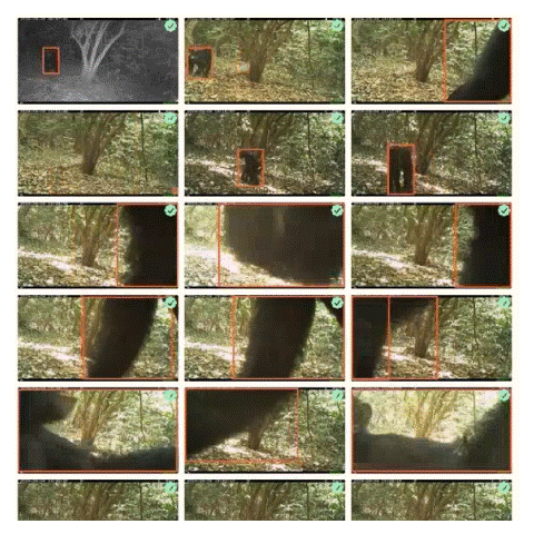
Eastern Africa chimps
The Biodiversity Consultancy partnered with Okala to monitor chimpanzee populations using camera trap data
Congo rainforest
Scalable AI species identification in the Republic of Congo

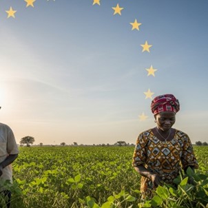
EUDR East Africa
EUDR compliance for 50,000 soya farms across Togo and Benin
Gold mine in Australia
FURA is a global gemstone mining company operating in Australia, Colombia, and Mozambique.

Brazil Rainforest
Camera trap videos of individually identified jaguars can support biodiversity credit projects

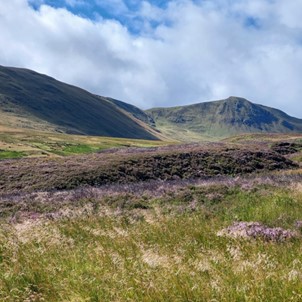
Scottish Estate
Scaling the use of bioacoustics, eDNA and camera traps for biodiversity monitoring in Scotland
Peer-reviewed studies underpinning our methodologies, ensuring outputs are scientifically robust and defensible under regulatory scrutiny.
Projects delivered across Africa, Asia, Europe, and the Americas, supporting approvals, compliance, and measurable biodiversity outcomes.
Agricultural sites assessed for deforestation risk and sustainability reporting, supporting compliance with EUDR and supply chain requirements.
See What Our Clients Say
Hear from organisations we have supported across complex projects, delivering reliable, defensible outcomes under regulatory and operational pressure.
We had a fantastic experience working with Okala, who supported us with camera trap surveys, including survey design, image processing and data analysis. They were extremely professional and communicative, delivering tagged images and access to their expert dashboard within a short space of time. We look forward to working with them on future projects.

We have had a great experience working with Okala. The process has been constructive and efficient. We have appreciated the collaborative nature of the work and the level of expertise from the Okala team. It has been great to work with a like-minded team who share our values.

We greatly appreciated Okala’s ability to adapt to the specific demands of the mining industry. Their flexibility and responsiveness enabled the timely delivery of key project components. The dashboard training session was very well received by our client, and the platform itself has proven to be an effective tool for visualizing the results of camera-trap monitoring. We look forward to continuing and expanding our collaboration with Okala.

This was an ambitious project where we could put AI to the test at very large scales. Okala's data platform allowed us to verify AI outputs and rapidly interact with the data using the intuitive interface.


Okala's expert gap analysis and guidance have greatly advanced Fura’s progress towards reaching our sustainability goals. Their professionalism and insight into biodiversity and carbon management exceeded our expectations.


Okala delivered cutting edge biodiversity, carbon and social baselines to understand how a 300,000 ha forestry concession in Gabon could be managed for sustainable development.


The full service - from fieldwork to reporting - was excellent. We look forward to working with Okala again.

Minimising biodiversity impact is an increasing challenge for our sector. Okala provided unrivalled transparency and reporting for our early-stage industrial project in Rwanda.


Okala delivered high-quality biodiversity baselines in just six months using eDNA, bioacoustics and camera traps. Their work will allow us to calculate the biodiversity value of the forest to inform land-management.

Answers To Your Biodiversity Assessment FAQs
Have questions about biodiversity assessment services? Here’s how our assessments support regulatory approval, risk management, and project decision making in practice.
Explore Related Biodiversity Solutions Across Your Project Lifecycle
Biodiversity projects rarely operate in isolation. Explore the additional support available across assessment, monitoring, or reporting to meet regulatory requirements, reduce risk, and maintain long term compliance across your sites.
End-To-End Biodiversity & Ecological Consulting For Approvals and Due Diligence
Access specialist consulting support across the full lifecycle of biodiversity assessments, from early stage baseline studies through to complex impact assessments and lender due diligence.
We design and deliver studies aligned with IFC PS6 and other regulatory frameworks, ensuring your project meets approval requirements while reducing risk and delays.
Environmental and social impact assessments aligned with international standards.
Critical habitat and ecological impact assessments for high risk projects.
Biodiversity baseline studies and survey design for early stage planning.
Regulatory Framework Aligned Biodiversity Reporting and Disclosure
Turn complex biodiversity data into clear, structured reports aligned with global regulatory and voluntary frameworks.
We support organisations in meeting TNFD, EUDR, GRI 304, and national reporting requirements, delivering transparent, audit-ready outputs for regulators, investors, and internal stakeholders.
Reporting aligned with TNFD, EUDR, GRI 304, and national requirements.
Audit-ready outputs for regulatory submissions and stakeholder disclosure.
Biodiversity metrics, mapping, and transparent documentation.
Scalable Biodiversity Monitoring Solutions and Long Term Data Programmes
Implement and manage continuous biodiversity monitoring programmes designed to track change over time and support ongoing compliance.
Using a multi-method approach including eDNA, camera traps, bioacoustics, and field surveys, we deliver reliable data streams and reporting across sites and landscapes.
Multi-method monitoring using eDNA, camera traps, and bioacoustics.
Continuous data collection, analysis, and programme management.
Ongoing and long term biodiversity tracking across sites and landscapes.
Unify and streamline compliance data across your supply chain.
Centralized platform for supply chain transparency
Integration with existing enterprise systems
API access for seamless data exchange

Expert guidance to navigate EUDR regulations with confidence.
Custom compliance strategies tailored to your industry
Regulatory insights and risk mitigation plans
Hands-on training for internal compliance teams
Book Your Initial 30-Minute Consultation and Move Your Project Forward With Confidence
Speak with our team about your project requirements, regulatory context, and timelines. We will provide clear, practical guidance on the best approach to assessment, compliance, and reporting.
